Nearview and Substructure offer clients high-resolution, seamless topo-bathy products for mapping shorelines and the land-water interface
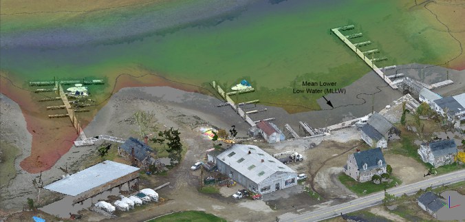 Nearview and Substructure developed survey-grade maps of the waterfront and intertidal zone of this marina using high-resolution aerial photogrammetry and multibeam sonar.
Capturing and developing seamless high-resolution nearshore, foreshore, and backshore topo-bathy digital surface and elevation models in the past has proved extremely challenging. Although NOAA Office for Coastal Management’s coastal LiDAR data sets provide critical elevation data required to produce datum-based shorelines, bathymetric points collected via Joint Airborne Lidar Bathymetry Technical Center of Expertise (JALBTCX) are spaced fairly wide in comparison to topographic points, and there are often large gaps in areas where there is significant wave action and high turbidity. With the collection of bathymetric point via multibeam sonar at sea by Substructure, and topographic points via small Unmanned Aerial System (UAS) LiDAR and photogrammetry of land by Nearview, we are able to provide continuous, consistent and accurate coverage across the land-water interface. Our methods are particularly well-suited for monitoring of coastal erosion, soil remediation surveys, survey of port and waterfront facilities, and mapping of nearshore, intertidal, and wetland habitats. Our aerial-marine survey approach provides an unparalleled level of detail of current and existing shoreline conditions, and can be used repetitively for detailed change analysis. Please contact us to discuss your project and mapping needs.